-
E-mail
513605359@qq.com
-
Phone
18320930025
-
Address
908-911, Building 6, SEG New City, Sanlian Community, Jihua Street, Longgang District, Shenzhen Pengjin Technology Co., Ltd
Shenzhen Pengjin Technology Co., Ltd
How to use DJI M400+P1 camera to complete high-precision mapping of 50 square kilometers in 4 days in an efficiency revolution?
Date: 2025-10-16Read: 9
1
Challenge: Pain points in the industry of large-scale surveying and mapping

The surveying and mapping work of large-scale projects often faces three major challenges:
-
inefficient:The traditional manual measurement method requires a large amount of manpower and material resources, takes a long time, and a project can take weeks or even months.
-
Uneven accuracy:The measurement of complex terrain areas is difficult and prone to errors, making it difficult to ensure the consistency of the overall results.
-
成本高昂:The long construction period brings huge manpower, time, and management costs, seriously affecting project efficiency.
How to quickly, accurately, and cost effectively obtain large-scale terrain dataBecoming the core demand of the industry.
2
Solution: Strong combination of flagship platform and professional camera
Faced with the above pain points, DJI Industry Application providesDJI M400 drone+DJI P1 full frame aerial survey cameraThe golden solution.

Why M400? ——A flight platform designed for professional level loads
The DJI M400 is not a consumer grade drone. It is a reliable platform designed for industrial level tasks, and its advantages are suitable for large-scale surveying and mapping
Load and battery life:The maximum load is 6 kilograms and the endurance is up to 59 minutes,Single flight can complete large-scale operationsThis greatly reduces the number of takeoffs and landings and battery swapping time.
Strong environmental adaptability:IP55 protection level, capable of handlingLight rain, strong wind(12 meters per second)Waiting for complex weather conditions to ensure the smooth execution of the homework plan.
reliability:The powerful obstacle avoidance system composed of ring scanning lidar, high-precision millimeter wave radar, and full-color low light fisheye vision sensor elevates the Matrice 400's obstacle avoidance capability to a whole new level,Can achieve wire level obstacle avoidance.
-
Convenient integration and control:Support DJI Pilot 2 APP, simple and efficient route planning, quick to learn, and reduce operational barriers.
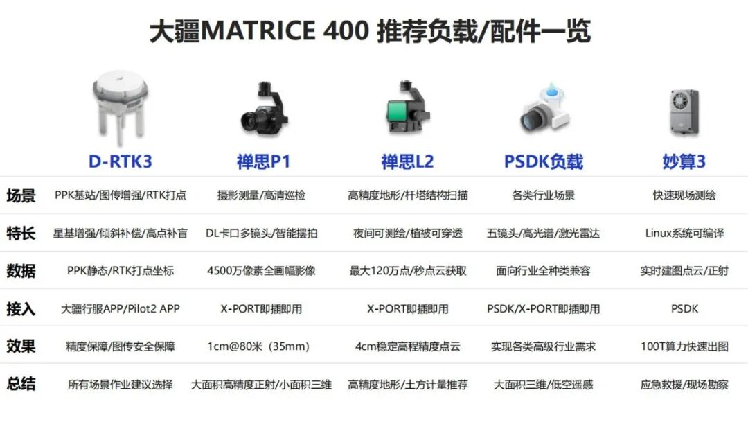
Why P1? - A "divine eye" specially designed for high-precision aerial surveying
The DJI P1 is a full frame aerial survey camera designed by DJI specifically for aerial survey modeling. It takes aerial survey efficiency and quality to new heights:
Full frame sensor:45 million pixel full frame sensor, paired with optional fixed focus lenses of 24mm/35mm/50mm, provides clear images with minimal distortion, ensuring data quality from the source.
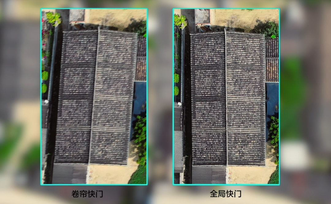
Global mechanical shutter:Core advantages!Eliminating common issues during high-speed flight photography“rolling shutter”So that the image will not deform and the image will be sharp,Specially suitable for high-precision modeling and orthophoto generation.
Intelligent swing shooting function:By shooting from multiple angles,Significantly increase the number of images of the same featureTo generate richer and more accurate 3D model textures, especially on the side of the terrain.
-
Deep integration with drones:Built in POS data and high-precision time synchronization system, each photo comes with high-precision position and orientation information,Significantly reduce or even eliminate the need for field deployment of image control pointsTruly achieving "image free control" operations and doubling efficiency.
3
Practical case: Large area orthophoto in a new district of a prefecture level city
Project RequirementsWithin 5 days, obtain high-precision 1:500 scale for 50 square kilometers of newly built urban areasDigital orthophoto(DOM)。
Traditional methods for estimationThree measurement teams are required, which will take at least 25 days, and it is difficult to ensure uniform accuracy.
M400+P1 scheme:
equipment1 set of DJI M400+1 P1 (35mm lens)
personnel2 pilots+1 data processor
homework:Flight altitude of 240 meters, 3cm resolution, 16 meters/s,Adopting intelligent swing shooting mode.
processDifferentiate multiple plots and fly 6-8 flights per day,Complete all field data collection in just 3 days.
-
handleUsing DJI Terra for aerial triangulation and model generation,Thanks to the high-precision POS data of P1, only a small number of image control points are needed for verification,11302 photos were processed in approximately 7 hours

efficiencyField efficiency improvement exceeds8 times.
precisionThe final result requires an accuracy requirement of 1:500 topographic map, with a mean square error of less than 5cm in the plane and less than 10cm in the elevation.
costThe overall cost has been reduced by about 60%.


The combination of DJI M400 and P1 is not just a hardware overlay, but alsoEfficiency, accuracy, and reliabilityThe fusion. It provides insights for large-scale surveying and mapping projects, freeing practitioners from heavy and inefficient fieldwork and focusing on data value mining and deepening industry applications.
Whether it's digital city construction, land and resource surveys, or large-scale projectsEngineering surveyChoosing M400+P1 means choosingIndustry productivity tools.