-
Phone
18910099057
-
Address
Guanghua Entrepreneurship Park, No. 28 Anningzhuang East Road, Haidian District
Product Categories
Beijing Zhonghe Technology Co., Ltd
FloodArea core1FloodArea 2D hydrodynamic flood inundation simulation software
NegotiableUpdate on 03/01
- Model
- Nature of the Manufacturer
- Producers
- Product Category
- Place of Origin
Overview
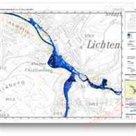
Simulation of overtopping type flood, breach type flood, rainfall type flood, FloodArea two-dimensional hydrodynamic simulation system software, applicable scope: two-dimensional hydrodynamic simulation (reproduction and estimation) of flood disasters, calculation of flood inundation area and depth, determination of critical rainfall (flood volume), determination of dynamic risk assessment, mapping of dam break simulation, hydrological editing
Product Details
1FloodArea 2D hydrodynamic flood inundation simulation softwareIntroduction:
2001yearPublished and applied to five continents20 countries and regions;
Two dimensional hydrodynamics based on gridSimulation and modeling tools;
Suitable for mountainous small watersheds without hydrological data, plateau flash flood areas, plain water network areas, and urban waterlogging risk areas. The size and resolution of the simulation area are not limited and can simulate up to20The actual area of billions of grid cells;
2、 FloodArea 2D hydrodynamic flood inundation simulation software features:
By simulating flood and waterlogging processes, reproduce and estimate the flooded area, depth, and corresponding inundation time caused by factors such as rainfall, reservoir overflow, or dam failure;
Determine the critical rainfall (flood volume) that can cause disasters;
Confirm the safe water level of the reservoir;
Flood dynamic risk assessment mapping;
Hydrological editing;
Simulation of overtopping and dam failure;
Flood simulation video production;
3、 FloodArea 2D hydrodynamic flood inundation simulation softwareApplication fields:
Rainstorm, decentralized, overtopping and dam break flood control;
Violation assessment of embankments and reservoir dams;
Flood disaster map and impact assessment project;
Large scale atlas projects (such asRheinatlas,Oderatlas,Elbeatlas);
4FloodArea 2D hydrodynamic flood inundation simulation softwareAdvantage:
1. Can be integrated into ArcGIS ® It can also run independently when paired with mainstream geographic information system analysis software;
2The free combination of all simulation methods: The causes of flood disasters are complex. The software hasThere are various simulation methods for flood control, such as rainfall type flood simulation, overtopping type flood simulation, and breach type flood simulation. You can use one of these modes separately or freely combine various simulation methods based on the cause of the flood to make the software simulation more realistic;
3Coupling with sewage discharge model: It can be bidirectionally coupled with sewage network model to solve the impact of simulating urban waterlogging on the simulation effect of sewage system waterlogging,
4Simultaneously using several precipitation curves
The precipitation in real flood prone areas may vary, and the software allows you to use multiple precipitation hydrological maps in independent sub areas simultaneously (such as copying the grid of hygrometers or radar images). You can input dynamic (temporal and spatial) precipitation data into the software in real time to simulate flood disasters;
5. Optimized computing power: The multiplier computing core can increase your modeling speed by several times, allowing you to complete simulations faster and simulate larger areas;
6The water level that changes over time: In flood disasters, the water level changes over time. During the modeling process, the software allows for the free combination of real-time water level, inflow water level, and outflow water level calculation options;
7Roughness related to water level (flow obstruction function): Roughness changes in real flood disasters in real time, such as rising water level, illegal treatment of embankments, or the occurrence of linear flow, which can all affect roughness. The software allows you to set thresholds, and you can also adjust the roughness based on the water level, such as by assigning values to the corresponding areas10,000 kSTThe roughness can be considered in the simulation to account for flow obstacles;
8The permeability that changes over time: The permeability of the underlying surface changes over time. When the software is simulating, you can input the permeability that changes over time;
9Time variation of runoff coefficient: The simulation of runoff coefficient over time no longer requires external scripts, making your simulation more stable and faster, and it also reduces rounding errors to almost zero;
10New file formats: allowing users to input more file formats in a more user-friendly manner;
11Eliminating separate preprocessing: Everything is integrated into the model core, which makes your simulation faster and more stable;
12More output information: Display detailed error messages;
13Network based manual: always online access to the latest version and easy to use;
14Free upgrade: Within one year, if there is an update to the software, you will enjoy a free upgrade to the same version of the software. If you want to upgrade the software to a more advanced version, you only need to pay the price difference, there is no need to purchase more software;
15Revision of animation tools: can be easily created by displaying simulation timeMP4-Video;
16In the toolbox64Bit calculation, in standard graphical user interface(GUI)In the background, it can be launched64Bit process;
17Input of dam failure point: Any dam failure point can be manually insertedDTM;
5、 Typical users:
Northeast Institute of Geography and Agroecology, Chinese Academy of Sciences, Inner Mongolia Normal University, Nanjing University of Information Engineering, Chifeng University, Yangtze River Academy of Sciences, Beijing Normal University, Beijing University of Civil Engineering and Architecture;
National Climate Center, Anhui Climate Center, Beijing Climate Center, Chongqing Climate Center, Jiangxi Meteorological Bureau, Jiangxi Climate Center, Fujian Climate Center, Guangxi Climate Center, Guangxi Institute of Meteorological Disaster Reduction, Guizhou Climate Center, Hainan Climate Center, Hebei Climate Center, Heilongjiang Climate Center, Henan Climate Center, Hunan Climate Center, Jiangsu Climate Center, Jilin Climate Center, Xinjiang Kashi Hydrology and Water Resources Survey Bureau, Ningxia Climate Center, Northwest Regional Climate Center, Qinghai Climate Center, Shaanxi Climate Center, Shanxi Climate Center, Shandong Climate Center, Shanghai Climate Center, Shenyang Regional Climate Center, Sichuan Climate Center, Tianjin Climate Center, Xizang Climate Center, Xinjiang Climate Center Yunnan Provincial Climate Center, Zhejiang Provincial Climate Center;
- FloodArea core1FloodArea 2D hydrodynamic flood inundation simulation software
- FloodAreaFloodArea 2D hydrodynamic simulation system software
Similar Product Recommend