-
E-mail
atlasinfo@atlasinfo.com.cn
- Phone
-
Address
Room 701, Guanhui Building, Building 3, No. 30 Shixing Street, Shijingshan District, Beijing
Product Categories
Beijing Atlas Information Technology Co., Ltd

3D models and BIM models
NegotiableUpdate on 09/19
- Model
- Nature of the Manufacturer
- Producers
- Product Category
- Place of Origin
Overview
1、 Product Introduction: What is a 3D model? 3D model: What we usually refer to as a 3D model refers to a manually generated 3D model, which is generated by specialized software such as 3D modeling tools
Product Details
Brief introduction
- What is a 3D model
3D model: What we usually refer to as a 3D model is a manually generated 3D model, which is generated by specialized software such as 3D modeling tools. As a collection of points and other information, 3D models can also be generated from emerging 3D data such as oblique photography, laser point clouds, BIM, etc.
- What is BIM model
BIM model: It is a three-dimensional building model established based on various relevant information data of the construction project, and simulates the real information of the building through digital information simulation. It has eight characteristics, including information completeness, information correlation, information consistency, visualization, coordination, simulation, optimization, and graphing.
It is not a two-dimensional representation of a construction project or the implementation of physical and functional characteristics, but rather a direct three-dimensional representation; It is also a process that provides a basis for all decisions throughout the entire lifecycle of a building, from construction to demolition.
2、 Product advantages
- BIM and oblique photography data fusion matching
BIM data and oblique photography data models usually use different coordinate systems, and before fusion and matching, coordinate system conversion operations are performed first. The product not only supports the coordinate conversion function of model data, but also supports the registration function of model data, which can facilitate the automatic matching of BIM models in the engineering coordinate system to the specified coordinate system. At this point, it is necessary to perform tiling and flattening operations on the tilted photographic model in the area where the BIM model is located. Similarly, slope protection parameters can also be set to achieve smooth transitions at data connections. The effective combination of oblique photography data and BIM data can be achieved. On the one hand, advanced carbon sequestration accounting models can be used to batch construct surface models of real-world buildings through oblique photography technology, which can be used as base maps; On the other hand, by using BIM data to generate the internal structure of buildings, more accurate data analysis and modeling can be achieved. This solution can be applied in the land industry to achieve comprehensive collection and refined management of land information; Indoor navigation, providing visual guidance; 3D city modeling greatly reduces the cost of modeling; In the pipeline industry, effective 3D modeling of indoor and underground pipelines can be carried out, and the flow of internal resources in pipelines can be simulated. When pipelines rupture, data and technical support can be provided for the rapid development of emergency plans.

Image: Fusion of oblique photography data and BIM model
- BIM and terrain fusion matching
The product supports the integration of BIM data with terrain data. When integrating BIM data with 3D terrain data, the functions of cutting, digging, inlaying, Boolean operations, and surface operations of TIN terrain and oblique photography models can easily achieve BIM embedding in terrain, oblique photography models, oblique photography models embedded in terrain, and other effects. Integrating BIM data with terrain data, BIM provides micro level data information, while terrain data provides location information of BIM models in the macro environment and surrounding environment. By integrating multiple sources of information, we provide users with a more realistic and accurate visual experience, as well as three-dimensional spatial analysis data support. As shown in the figure below, the BIM model of the hydropower station is integrated with three-dimensional terrain data to provide data support for the construction, operation, and management stages of hydropower enterprises.
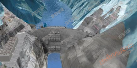
Image: BIM data and terrain data fusion
- BIM and water surface integration
The product supports the integration of BIM data with water surface data. For water surface data, the product supports creating water surface symbols, setting parameters such as water wave size and water surface color, and can create water surface symbols with real-time reflection and dynamic ripples.

Image: BIM data and water surface data fusion
- BIM and IoT integration
BIM digitizes and models buildings to indicate the locations of various elements within the entire building. The Internet of Things technology collects various building operation data through sensors and reflects them to local operation centers and remote users in real time through the Internet. Integrating BIM technology and IoT technology to achieve smart buildings.
BIM is the foundation of IoT applications, and with the help of BIM models, IoT applications can deeply penetrate the interior of buildings. As shown in the figure below, the access control equipment inside the building can be seen through the BIM model. With the help of IoT technology, access control information and personnel passage status can be obtained. Combine the two to obtain all the information of the access control model, including location information, attribute information, etc.

Image: BIM and Internet of Things
- BIM and IoT integration
With the continuous development of technology, surveillance and cameras in every corner of the city generate a large amount of real-time monitoring videos every day, containing rich information. This product integrates video data with oblique photography data, effectively utilizing massive video information while achieving real-time updates of monitoring area information.

Image: Fusion of oblique photography and video data
Similar Product Recommend