-
E-mail
atlasinfo@atlasinfo.com.cn
- Phone
-
Address
Room 701, Guanhui Building, Building 3, No. 30 Shixing Street, Shijingshan District, Beijing
Product Categories
Beijing Atlas Information Technology Co., Ltd
RSP Satellite Remote Sensing Intelligent System
NegotiableUpdate on 09/19
- Model
- Nature of the Manufacturer
- Producers
- Product Category
- Place of Origin
Overview
The Satellite Remote Sensing Intelligent System (RSP) product system integrates remote sensing image management system, remote sensing image processing system, remote sensing image intelligent interpretation and analysis system, and remote sensing image application service system, aiming to provide users with one-stop, efficient, and intelligent remote sensing product services
Product Details
Satellite Remote Sensing Intelligent System (RSP)The product system integrates remote sensing image management system, remote sensing image processing system, remote sensing image intelligent interpretation and analysis system, and remote sensing image application service system, aiming to provide users with one-stop, efficient, and intelligent remote sensing product services.
1、 RSP Remote Sensing Image Management System: Building an Ordered Digital Warehouse
The company's ATLAS-RSP remote sensing image management system relies on its independently developed spatiotemporal cloud platform, using advanced data storage and indexing technology, automatic RPC correction technology for raw data, and data slicing free publishing technology to achieve rapid storage, retrieval, and distribution of remote sensing data. The system supports multiple remote sensing data formats and provides data security guarantees to ensure the safety of user data
And complete. Through an intuitive user interface, users can easily manage their remote sensing data assets, greatly improving work efficiency.
The main features of the ATLAS-RSP remote sensing image management system are:
1. Efficient storage: With powerful data storage capabilities, it can easily meet the storage needs of massive remote sensing data.
2. Intelligent retrieval: Supports multi-dimensional retrieval and quickly locates the required remote sensing data.
3. Data security: Provide multiple security guarantees to ensure data security is not compromised.
4. Version control: Supports version management of data, making it easy to track changes in data and keep records.
5. Automated management: Supports automatic acquisition, update, and deletion of data, greatly improving management efficiency.


2、 RSP remote sensing imagecomprehensiveProcessing system: Building a sophisticated data sword
The ATLAS-RSP remote sensing image processing system is a self-developed, full process, efficient and fast remote sensing data processing platform. Its core part is a massive remote sensing image automatic processing algorithm based on high-performance cluster/GPU computing environment. The platform adopts advanced digital photogrammetry technology, multi task scheduling technology, and high-performance computing technology, integrating data production, task management scheduling, and result quality inspection. By reasonably allocating computing and data resources, it achieves large-scale, efficient, and intelligent remote sensing data processing.
The main functions of the system include regional network adjustment, orthorectification, image fusion, uniform light and color, intelligent tiling, quality inspection, stereo image matching, etc. In addition to the conventional production process, 63 data processing modules and functional toolsets have been developed according to business development and customer needs, which facilitate users to process various types of data and solve different processing needs.


IIIRSPRemote sensing image intelligent interpretation system(Image-AI)Exploring the Treasure of Deep Knowledge
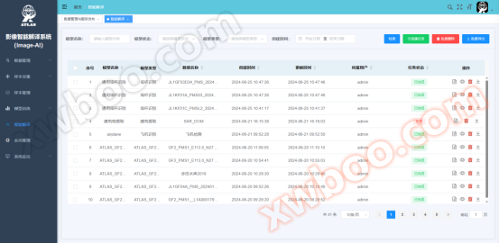
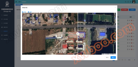
Today's technology is advancing rapidly, and the rapid development of artificial intelligence technology has also penetrated into various fields. Among them, the intelligent interpretation technology of remote sensing images, as an important application field of artificial intelligence, has become a reality. The remote sensing image intelligent interpretation system (Image AI) developed by the company adopts an independently controllable and advanced deep learning framework and model algorithm technology, gradually completing the core infrastructure of interpretation data management, sample collection, sample management, model training, model management, remote sensing interpretation, etc. A large number of image interpretation models are trained through Image AI to achieve automatic recognition and scene perception of remote sensing images. These models can automatically identify land cover types, distributions, and changes based on the features in the images.
4、 Remote sensing data application: creating infinite possibilities for the future
The application of remote sensing data is the ultimate goal of remote sensing technology, aimed at providing strong support and solutions for various industries. The company is committed to deeply integrating remote sensing technology with various industries and creating infinite possibilities for the future.
Beijing Atlas Information Technology Co., Ltd. has actively built an application service platform. At present, the company has developed and completed the remote sensing satellite and ground monitoring station water quality and water pollution monitoring service system and remote sensing satellite and ground monitoring station air quality pollution monitoring service system. The former can invert indicators related to water quality, such as permanganate index, dissolved oxygen, ammonia nitrogen, total phosphorus, total nitrogen, chlorophyll-a, chemical oxygen demand, transparency, etc; The latter can invert indicators related to air quality such as PM2.5, PM10, SO2, NO2, O3, CO, etc.


Similar Product Recommend