-
E-mail
atlasinfo@atlasinfo.com.cn
- Phone
-
Address
Room 701, Guanhui Building, Building 3, No. 30 Shixing Street, Shijingshan District, Beijing
Product Categories
Beijing Atlas Information Technology Co., Ltd

Tilt photography and 3D image modeling scheme based on unmanned aerial vehicles
NegotiableUpdate on 09/19
- Model
- Nature of the Manufacturer
- Producers
- Product Category
- Place of Origin
Overview
1、 Overview of the Plan: Tilt photography technology is an emerging high-tech in the field of international surveying and remote sensing. It combines traditional aerial photography and close range measurement technology, overturning the limitation of traditional orthophoto that can only be captured from a vertical angle. By installing multiple sensors on the same flight platform, images are collected from five different angles: vertical, forward, left, right, and rear
Product Details
1、 Overview of the Plan
Tilt photography technology is a newly developed high-tech in the field of international surveying and remote sensing, which integrates traditional aerial photography and close range measurement technology. It overturns the limitation of traditional orthophoto that can only be captured from a vertical angle. By installing multiple sensors on the same flight platform, images are collected from five different angles: vertical, forward, left, right, and rear. Among them, vertical photography images can be processed using traditional aerial photogrammetry techniques to produce 4D (DEM, DOM, DLG, and DRG) products; Four oblique photography images, including front view, left view, right view, and rear view, with a tilt angle between 15 ° and 45 °, can be used to obtain rich texture information of the side of the ground object.
Through efficient and automated 3D modeling technology, a true 3D spatial scene with accurate geographical location information of land features can be quickly constructed, intuitively grasping the detailed features of the terrain, landforms, and all buildings in the target area. This can provide real-time, detailed, accurate, and realistic spatial basic geographic information data support and public services for power and water conservancy engineering construction, geological disaster emergency command, etc.
IISolution Description
The drone based oblique photography and 3D image modeling scheme comprehensively perceives complex scenes in a wide range, high-precision, and high-definition manner. The data results generated through efficient data acquisition equipment and professional data processing flow intuitively reflect the appearance, position, height, and other attributes of the land cover, providing guarantees for real effects and surveying level accuracy. At the same time, it effectively improves the production efficiency of the model. For a small and medium-sized city modeling work that can only be completed in one or two years through manual modeling, it only takes three to five months to complete through oblique photography modeling, greatly reducing the economic and time costs of 3D model data collection.
IIIScheme composition
The drone based oblique photography and 3D image modeling scheme consists of three systems: data acquisition system, data processing system, and data application system.
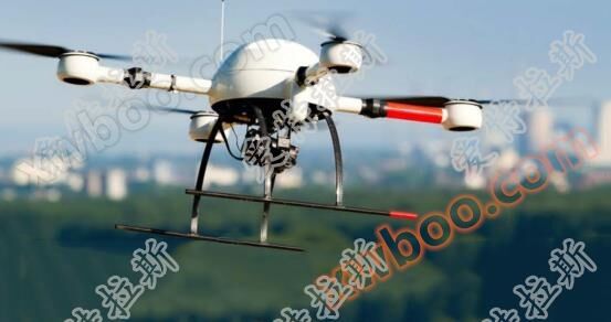
Data acquisition system: MD4-100 quadcopter drone+5-lens tilt camera (proxy product)
The domestic and international oblique photogrammetric market has advanced technology design and concepts. The oblique photogrammetric camera equipped with MD4-100 quadcopter unmanned aerial vehicle is an aerial camera with high production efficiency, flexible production methods, and fast maneuverability, which can fully meet the rapid acquisition of oblique image data. A quadcopter unmanned aerial vehicle is a multi rotor aircraft capable of vertical takeoff and landing. The system adopts a modular multi-core design, which detects and controls the attitude through collected information such as gyroscope, accelerometer, GPS position, direction sensor, altitude sensor, etc. Four brushless motors are used as power engines, and speed control is achieved through four high-precision electric adjusters, thus achieving stable flight and autonomous driving flight functions, and completing various tasks. The quadcopter unmanned aerial vehicle is equipped with a black box that can record all data during mission execution and transmit it in real-time to the ground control station. Quadrotor system is composed of all carbon fiber airframe mechanism, ground station system and software, modular airborne equipment, auto drive system and other external equipment. The drone is equipped with a Sony 2010 megapixel APS-C format digital camera x5, a 20mm F2.8 fixed focus lens x5, which can be remotely controlled or automatically controlled on the ground to take photos simultaneously. The 5 cameras can be turned on at the same time with one click, and the output photo data can be read and output with one click. The all carbon fiber structure dedicated self stabilizing gimbal is used for drone tilt photography and fast 3D modeling.
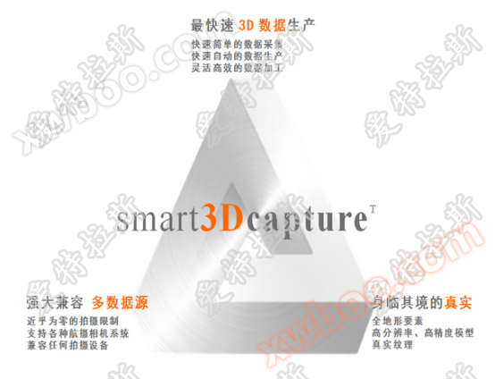
Data processing system: Smart3Dcapture 3D modeling processing software (a proxy product, but domestic independent products can also be selected)
Using oblique images as the main data source, intelligent 3D model construction is achieved using Smart3DCapture from France. Smart3DCapture is a fast 3D scene processing software developed over 25 years, based on GPU graphics processing units. It can generate the most realistic 3D scene models from simple continuous images without human intervention. Without relying on expensive and inefficient laser point cloud scanning systems or POS positioning systems, the most realistic real 3D model can be restored by simply relying on simple continuous 2D images. Unlike traditional techniques that rely solely on elevation to generate 2.5-dimensional models lacking side structures, Smart3DCapture ™ It can compute and generate ultra-high density point clouds based on real images, and use them to generate high-resolution real 3D models based on real image texture. The full feature level restoration of real scenes at the original image resolution has reached an infinite degree of closeness to reality.
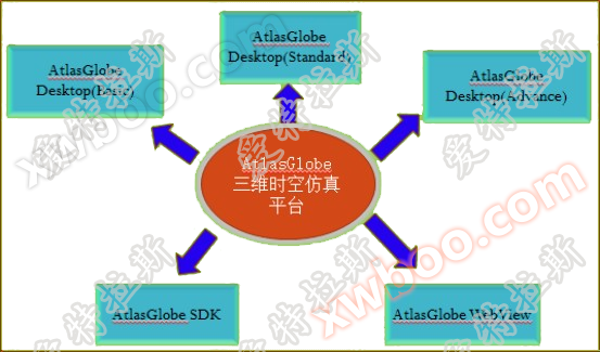
Data application system: Atlas Global 2D and 3D integrated display system (independent product)
Display and manage 3D real-world data on the ATLASGlobe platform, enabling 3D data visualization roaming, multi-source data fusion, and spatial query statistical analysis. Atlas Technology has independently researched and developed two-dimensional and three-dimensional integrated display system products with full independent property rights, focusing on the integration technology of "spatial analysis multidimensional, business model temporal, and event simulation virtualization", truly realizing the GIS visualization application innovation model of "Internet of Things front-end perception, application temporal analysis, management virtual simulation, multi-dimensional GIS spatial analysis" integration, and truly bringing three-dimensional development into the multi-dimensional GIS era.
4Features of the Solution
>>The tilt camera of the MD4-1000 quadcopter drone is an aerial camera with high production efficiency, flexible production methods, and fast maneuverability, which can fully meet the fast acquisition of tilt image data;
>>French company Acute3D Smart3DCapture achieves intelligent 3D model construction, which can generate the most realistic real-life 3D scene models from simple continuous images without human intervention;
>>The Atlas Global 2D and 3D integrated display system enables seamless and seamless 3D visualization browsing of massive, multi-source, and multi-scale 3D spatial data, as well as application operations such as query positioning, roaming flight, and spatial analysis in 3D scenes.
5Application field
With the significant improvement of computer processing capabilities and the accelerated popularization of oblique photogrammetry, its applications in industries such as real estate, land use, urban management, smart cities, planning, water conservancy, and energy extraction have seen greater development.
Similar Product Recommend