-
E-mail
atlasinfo@atlasinfo.com.cn
- Phone
-
Address
Room 701, Guanhui Building, Building 3, No. 30 Shixing Street, Shijingshan District, Beijing
Product Categories
Beijing Atlas Information Technology Co., Ltd

GEOTB Space Big Data Products
NegotiableUpdate on 09/19
- Model
- Nature of the Manufacturer
- Producers
- Product Category
- Place of Origin
Overview
The data products provided by Beijing Atlas Information Technology Co., Ltd. mainly come from the basic database of satellite remote sensing image products and vector product database formed by the accumulation of data related to data production and processing projects undertaken by the company for many years
Product Details
The data products provided by Beijing Atlas Information Technology Co., Ltd. mainly come from the basic database of satellite remote sensing image products and vector product database formed by the accumulation of data related to data production and processing projects undertaken by the company for many years. At present, the database mainly consists of satellite remote sensing image products, electronic map vector data, administrative boundary data products, 3D models, and BIM model products. Satellite remote sensing image products mainly include domestic Jilin-1 series, high-resolution series, Beijing series, resource satellites, and foreign Worldview series satellite images; Electronic map vector data includes thematic maps of electronic maps at various scales; Administrative boundary data products include attribute data of five levels of administrative units in provinces, cities, counties, and rural areas; 3D models and BIM model products contain various types of model data.
1Satellite remote sensing image products
1.Product Introduction
ATLAS satellite remote sensing image products are solution level products that meet users' one-stop procurement needs, based on the company's integration of authorized remote sensing image supplier channel resources in the industry. The company's characteristic image data production and processing technology based on independent intellectual property rights meets the large-scale production of massive remote sensing image data, providing multi temporal, multi data source, standardized, and effective satellite image products, as well as continuous and rapid update services and value-added interpretation and extraction services.
2.Product Features
- Mainly using domestic commercial satellite data sources, while providing international commercial satellite data sources as supplements
- Efficient and stable autonomous remote sensing image data processing technology
- Full color and multispectral images are cloud free, and effective pixel data fragments are fully utilized
- We can provide original distribution standard products, as well as fused and embedded remote sensing image base maps
- We can provide value-added services such as calibration, orthography, inlaying, change discovery, interpretation and extraction according to demand
3.Main data sources
- Domestic commercial satellite data: high-resolution series, resource series, Gaojing series, Beijing No.2, etc
- International commercial satellite data: WorldView series, GeoEye series, SPOT series, Landsat series, MODIS series, etc
- High score number two:


- WorldView3:


- Resolution:
- 全色: 5m、0.8m、1m、2m
- Multispectral: 2m, 3.2m, 5.8m, 8m, 10m, 16m
- Main parameters
- Resolution: Full color: 5m, 0.8m, 1m, 2m; Multispectral: 2m, 3.2m, 5.8m, 8m, 10m, 16m
- Coordinate System: Provided according to customer requirements, default WGS84
- Map Projection: Provided according to customer requirements, default latitude and longitude
- Data format: GeoTIFF or img
- Depth: 8Bit
IIElectronic map vector data product
1.Product Introduction
The ATLAS electronic map vector data product is a set of standardized data products independently developed and produced to meet the widespread demand for basic data in various industries' geographic information systems, based on the specific application characteristics of each industry. The product is based on the company's project data accumulation over the years, according to the unified standardized product production process, using remote sensing image intelligent interpretation technology for vector production, and combining manual collection with Internet technology for attribute update.
2.Product Features
The product covers a global scope with a time span of 2014 to present. It has authoritative standards, rich layers, complete attributes, reasonable architecture, detailed maps, accuracy and reliability, and detailed documents. It can be directly used for various GIS system application base maps, meet business function calls, and can also be used for base map display.
3.Classification of main elements
- Water system: rivers, ditches, lakes, reservoirs, marine elements, etc
- Residential areas and facilities: residential areas, industrial and mining facilities, agricultural facilities, public services and facilities, etc
- Transportation: railways, intercity highways, urban roads, rural roads, etc
- Boundary and administrative regions: foreign regions, national administrative regions, provincial administrative regions, prefecture level administrative regions, county-level administrative regions, township level administrative regions
- Landforms: natural landforms, artificial landforms, etc
- Vegetation and Soil Quality: Agricultural and Forestry Land, Urban Green Space, etc
- POI: Government agencies, public services; Social organizations; medical hygiene Scientific research education; Postal and telecommunications, residential areas, convenient facilities, etc


4.Main parameters
- Coordinate System: Provided according to customer requirements, default WGS84
- Map Projection: Provided according to customer requirements, default latitude and longitude
- Data format: default GDB or SHP format, can support various format conversions as needed, suitable for various general GIS platforms
5.Ordering Method
- Based on meeting customer requirements, provide as needed. Generally designated according to administrative regions and scales.
- Provide free or discounted data update services based on specific project requirements, usually updated 1-4 times a year.
- For specific and detailed indicators or customized project requirements, please feel free to call for consultation.
three、Administrative boundary data product
1.Product Introduction
The ATLAS administrative boundary data product is developed by our company based on field measurement data and relevant geographical maps, using human-computer interaction to vectorize administrative boundary maps and ultimately obtain national administrative boundary data products. It mainly includes the vector boundaries of the national five level administrative divisions, and includes a list of attributes (administrative division names, administrative division codes), using the WGS-84 global GPS universal coordinate system.
2.Product Features
- Coordinate system: WGS84 coordinate system
- Applicable scale: Meet the requirements of 1:1000000 scale mapping
- Data format: Supports GDB format read by ArcGIS software
- Data attributes: including administrative division name and administrative division code
- Latest data timeliness: December 2019
-
Five level administrative divisions: ATLAS administrative division boundary data products cover five level administrative divisions:
- There are a total of 34 provincial-level administrative regions, including 23 provinces, 5 autonomous regions, 4 municipalities directly under the central government, and 2 special administrative regions;
- There are a total of 333 prefecture level administrative regions, including 7 regions, 3 leagues, 30 autonomous prefectures, and 293 prefecture level cities;
- There are a total of 2844 county-level administrative regions, including 1312 counties, 117 autonomous counties, 49 banners, 3 autonomous banners, 389 county-level cities, 971 municipal districts, 1 forest area, and 1 special zone;
- There are a total of 38773 township level administrative regions, including 8102 townships, 966 ethnic townships, 20988 towns, 8562 streets, 153 Sumu, 1 ethnic Sumu, and 1 county jurisdiction office.
- There are approximately 750000 village level administrative districts, including administrative villages and communities.


3.Data update
Since the first version of the ATLAS administrative boundary data product was produced in 2015, our company has been responsible for maintaining and updating it, updating 1-2 versions annually. The latest version number is [2019-V1].
The main maintenance reference basis is:
- National Bureau of Statistics - "Statistical zoning and urban-rural division codes", updated annually, latest version on June 30, 2020;
- Ministry of Civil Affairs - "Administrative Division Code of the People's Republic of China", updated irregularly, latest version in November 2020;
- Ministry of Civil Affairs - "Corrections to the Administrative Divisions of the People's Republic of China", 2016;
- National Ministry of Natural Resources (formerly National Bureau of Surveying, Mapping and Geoinformation) - National 1:1 million vector database;
- National Basic Geographic Information Center - National 1:250000 Vector Database;
- Announcement of administrative division changes by the State Council or competent authorities at all levels;
- China Map Publishing House, Special Atlas of National Administrative Divisions;
- other.
4.Product after-sales service:
- Free lifetime data repair and permanent backup of purchased data; If the buyer's data disc is damaged, we guarantee to provide the same data disc for free in the shortest possible time;
- Provide free coordinate system conversion services;
- Provide free data format conversion services for general GIS software;
5.Application Direction
Educational research, resource census, urban management, GIS mapping, etc
6.Ordering Method
Order according to the required administrative area and administrative division level: Orders can be placed by province, prefecture, or city, or by specifying a specific administrative division level.
43D models and BIM models
1.Product Introduction
Time Space Big Data Product (hereinafter referred to as the Product)
BIM (Building Information Modeling) uses various relevant information data of construction projects as the model basis, and records the geometric and attribute information of building components in detail and accurately, and displays them in a three-dimensional model format.
For BIM, the entire lifecycle of BIM, from design, construction to operation and maintenance, is focused on the refinement of individual BIM models, but it cannot be separated from the macro geographical environmental elements surrounding it. 3D GIS has always been dedicated to the study of macro geographic environments, providing various spatial query and analysis functions. In the planning, construction, and operation stages of BIM, 3D GIS can provide decision support, so BIM requires 3D GIS; For 3D GIS, BIM data is another important source of data, which can enable 3D GIS to move from macro to micro and achieve refined management. Therefore, 3D GIS+BIM can generate infinite possibilities.
2..Product Features
- BIM and oblique photography data fusion matching
BIM data and oblique photography data models usually use different coordinate systems, and before fusion and matching, coordinate system conversion operations are performed first. The product not only supports the coordinate conversion function of model data, but also supports the registration function of model data, which can facilitate the automatic matching of BIM models in the engineering coordinate system to the specified coordinate system. At this point, it is necessary to perform tiling and flattening operations on the tilted photographic model in the area where the BIM model is located. Similarly, slope protection parameters can also be set to achieve smooth transitions at data connections. The effective combination of oblique photography data and BIM data can be achieved. On the one hand, advanced carbon sequestration accounting models can be used to batch construct surface models of real-world buildings through oblique photography technology, which can be used as base maps; On the other hand, by using BIM data to generate the internal structure of buildings, more accurate data analysis and modeling can be achieved. This solution can be applied in the land industry to achieve comprehensive collection and refined management of land information; Indoor navigation, providing visual guidance; 3D city modeling greatly reduces the cost of modeling; In the pipeline industry, effective 3D modeling of indoor and underground pipelines can be carried out, and the flow of internal resources in pipelines can be simulated. When pipelines rupture, data and technical support can be provided for the rapid development of emergency plans.

Image: Fusion of oblique photography data and BIM model
- BIM and terrain fusion matching
The product supports the integration of BIM data with terrain data. When integrating BIM data with 3D terrain data, the functions of cutting, digging, inlaying, Boolean operations, and surface operations of TIN terrain and oblique photography models can easily achieve BIM embedding in terrain, oblique photography models, oblique photography models embedded in terrain, and other effects. Integrating BIM data with terrain data, BIM provides micro level data information, while terrain data provides location information of BIM models in the macro environment and surrounding environment. By integrating multiple sources of information, we provide users with a more realistic and accurate visual experience, as well as three-dimensional spatial analysis data support. As shown in the figure below, the BIM model of the hydropower station is integrated with three-dimensional terrain data to provide data support for the construction, operation, and management stages of hydropower enterprises.

Image: BIM data and terrain data fusion
- BIM and water surface integration
The product supports the integration of BIM data with water surface data. For water surface data, the product supports creating water surface symbols, setting parameters such as water wave size and water surface color, and can create water surface symbols with real-time reflection and dynamic ripples.

Image: BIM data and water surface data fusion
- BIM and IoT integration
BIM digitizes and models buildings to indicate the locations of various elements within the entire building. The Internet of Things technology collects various building operation data through sensors and reflects them to local operation centers and remote users in real time through the Internet. Integrating BIM technology and IoT technology to achieve smart buildings.
BIM is the foundation of IoT applications, and with the help of BIM models, IoT applications can deeply penetrate the interior of buildings. As shown in the figure below, the access control equipment inside the building can be seen through the BIM model. With the help of IoT technology, access control information and personnel passage status can be obtained. Combine the two to obtain all the information of the access control model, including location information, attribute information, etc.
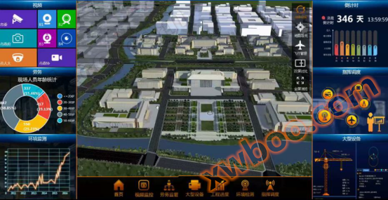
Image: BIM and Internet of Things
3.functional module
- 3D data coordinate conversion function module
The fusion and matching of multi-source data in 3D scenes should first involve coordinate transformation, which unifies BIM, oblique photography models, point clouds, and other GIS data into a coordinate system. The product provides coordinate conversion for various 3D data, including models, grids, images, point clouds, oblique photography models, etc.
- Tilt photography data and terrain fusion matching function module
Support the fusion of oblique photography data and 3D terrain data. Tilt photography data provides surface models of real-world buildings, while terrain data provides location information of oblique photography data in the macro environment and surrounding environment. By integrating multiple sources of information, we provide users with a more realistic and accurate visualization experience, as well as three-dimensional spatial analysis data support.
- Tilt photography data and road/water surface fusion matching function module
The oblique photography data model supports operations such as cropping, digging holes, inlaying, and removing suspended objects, and supports real-time preview. Before executing the operation, the processed data effect can be seen first. For example, building roads on a tilted photography model, expanding the 3D road surface based on the designed 3D road centerline, inlaying the 3D surface with the tilted photography model, and setting slope protection parameters. After the tiling is completed, overlay the road model to view the final effect of the road.
- Tilt photography data and video fusion function module
The product integrates video data with oblique photography data, effectively utilizing massive video information while achieving real-time updates of monitoring area information.
4.Case Showcase


5.Application Direction
Land industry, 3D city modeling, pipeline industry, hydropower and water conservancy, Internet of Things.
Similar Product Recommend